|
 In addition to customary public information channels, e.g.
press releases, processed and clear flood information is given
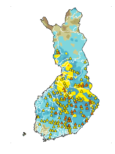
by a new public Public flood information. Up-to-date thematic runoff map
indicates the areas where flood in forecasted to occur. The
Public flood information includes: In addition to customary public information channels, e.g.
press releases, processed and clear flood information is given
by a new public Public flood information. Up-to-date thematic runoff map
indicates the areas where flood in forecasted to occur. The
Public flood information includes:
- water level and discharge observed and forecast, hazard
limits
- static flood extents
- real-time and dynamic flood extents if available (satellite
images, flood extents derived from satellite images, flood
extent simulated using model and DEM)
- flood warnings
General information
 Project concerning flood mapping is ongoing and therefore maps presented
in this service are only indicative and they should not be used
for civil protection or any other purposes. Project concerning flood mapping is ongoing and therefore maps presented
in this service are only indicative and they should not be used
for civil protection or any other purposes.
FloodMan (Contract: EVG1 - CT - 2002 - 00085) |